Some background on Neighbourhood Development Plans
The Localism Act of 2012 gives towns and villages such as ours the opportunity to have a greater say in the future development of their area. This is done through a Neighbourhood Development Plan which defines such items as where we would like new housing to be built; the mix of housing types needed; the location of retail or commercial premises; green space to be protected; and the infrastructure needs to support growth of the town. A properly prepared and adopted Neighbourhood Development Plan has legal status alongside SODC’s Local Plan and will eventually sit alongside the Local Plan 2033 as a part of the Local Development Scheme
Keep an eye on the Neighbourhood Planning Bill that has gone through Parliament by clicking here
Here are some links that may be useful to you:
To see a presentation on Neighbourhood Planning please click here
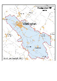
Watlington Neighbourhood Plan designated area
See also the Maps tab
Watlington Parish Council submitted to SODC a request for approval of all land within the parish boundary as the Designated Area for a Watlington Neighbourhood Development Plan (WNDP). This followed a year long discussion between ourselves, SODC officers, SODC Councillors, and the Parish Councils (or Meetings) of Pyrton, Cuxham and Britwell Salome. This discussion included requests for clarification and information from the Department for Communities and Local Government in London.
The issue behind this discussion was the idea that in our WNDP we should include parts of the adjacent parishes that bordered on Watlington to give us some local control of the extent to which the communities merged into each other. In January the other three parishes decided they did not want to be included in a Watlington area NP, so we submitted a request for approval of a Designated Area based on the parish boundary.
SODC were then concerned that this would not be acceptable to a central government examiner as it excluded two of the sites identified by their owners in the SHLAA as suitable for housing development (WAT7 and WAT8).
These two excluded areas fall within the Pyrton parish.
All parties to the continued debate, that has taken place since January 2013, agreed that proceeding with Watlington Parish alone was the only option available. We accordingly resubmitted the application and obtained SODC approval for this parish only area in late October 2013.
In 2014 a few minor changes to the parish boundary were made by SODC. These transferred the sports field and a few houses in Christmas Common into Watlington Parish, and took a single home near Russells Water from Watlington into Swyncombe. During 2015 the designated area for the Watlington Neighbourhood Plan was revised to include these changes.
The WNDP designated area includes the settlements of Christmas Common, Greenfield and Howe Hill together with some parts of Northend and Pishill